No products
Shetland Books & Maps
- Latest Releases
- Signed Copy Event Pre-orders
- Orkney Guidebooks, Travel Books & Maps
- Calendars, Gifts & Souvenirs
- Orkney Christmas Cards
- Orkney Fiction, Poetry, Folklore & Myths
- George Mackay Brown
- Children's
- Local Author - non-Orkney Related Titles
- Orkney Life, People & Places
- Orkney History
- Maritime
- Photos, Art, Music, Food & Sport
- Nature
- Shetland Books & Maps
- Sale
- 'The Orcadian' Subscriptions
Shetland Books & Maps There are 29 products.
Subcategories
-
Northern Scotland, Orkney & Shetland - 1 -...
Ordnance Survey Map. Northern Scotland, Orkney & Shetland, 1, OS Road Map. 1:250 000 scale, 1cm to 2.5km - 1 inch to 4 miles.
£ 7.99 -
Orkney And Shetland: Landscapes In Stone
This book tells the incredible geological story of the most northerly outposts of the British Isles. By Alan McKirdy. Paperback.
£ 6.99 -
Saint-Faust In The North 1803-1804
'Orkney and Shetland in danger'. The adventure of Saint-Faust, who temporarily diverted British Troops and created the threat of a potential attack on Shetland, Orkney and the North of Scotland with a small Franco-Batavian squadron during the Napoleonic War. Hardback, by P Fereday.
£ 20.00 -
The Cod Hunters
The incredible story of the Shetlanders who fished for cod around Faroe, Rockall, Iceland and Greenland. By John Goodlad.
£ 15.00 -
Orkney and Shetland: Cambridge County...
Cambridge Country Geographies reissued 1920s Guide. By J.G.F Moodie Heddle & T. Mainland.
£ 12.99 -
Philip's Orkney & Shetland Leisure Map
Leisure and tourist map featuring places of tourist and historic interest. Orkney and Shetland. 1:160 000 scale. 2 1/2 miles to 1 inch.
£ 6.99 -
Orkney and Shetland Weather Words
A comparative dictionary. Glep-de-wadder: a bright piece of rainbow at some distance from the sun. By John W. Scott. Paperback.
£ 35.00 -
Orkney and Shetland: British Regional Geology
Orkney and Shetland by The Institute of Geological Sciences.
£ 7.00 -
Shetland - Unst, Yell and Fetlar - 470 -...
Ordnance Survey Explorer Series Map Shetland - covering Unst, Yell & Fetlar. 1:25 000 4cm to 1km - 2 1/2 inches to 1 mile
£ 12.99 -
Shetland - Mainland North West - 469 - OS...
Ordnance Survey Explorer Series Map Shetland - Mainland North West - covering North Roe & Sullom Voe. 1:25 000 4cm to 1km - 2 1/2 inches to 1 mile
£ 12.99 -
Shetland - Mainland North East - 468 - OS...
Ordnance Survey Explorer Series Map Shetland - Mainland North East - covering Whalsay & Out Skerries. 1:25 000 4cm to 1km - 2 1/2 inches to 1 mile
£ 12.99 -
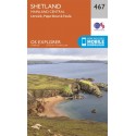
Shetland - Mainland Central - 467 - OS...
Ordnance Survey Explorer Series Map Shetland - Mainland Central - covering Lerwick, Papa Stour and Foula. 1:25 000 4cm to 1km - 2 1/2 inches to 1 mile
£ 12.99


