
First images from Hampshire ROV survey released

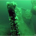
The first images from an archaeological survey of the wreck of HMS Hampshire have been released.
Carried out by the Archaeology Institute UHI, in partnership with Seatronics, Teledyne RESON, Roving Eye Enterprises Ltd and Triscom Marine Ltd, the work offers new information and data concerning the wreck and provides insights into the mine damage at the bow of the vessel, the impacts of salvage activities on the wreck, and the natural deterioration caused by the marine environment.

The Roving Eye Enterprises remotely operated vehicle (ROV) survey confirmed that the Hampshire capsized as she sank and lies, with an upturned hull, on the seabed in approximately 60m of water.
The hull is damaged in places throughout the length of the vessel, exposing various elements of the interior, including torpedo tubes and machinery. Guns from the ship’s secondary armament were also identified on the surrounding seabed at a distant of up to 30m from the main body of the wreck.
Further survey work, using the Seatronics Predator ROV, is in the planning stage.
Permission to undertake the survey was granted, under licence, by the Ministry of Defence.
HMS Hampshire sank on June 5, 1916, after striking a mine off Marwick Head. The warship was en route to en-route to Archangel, in Russia, carrying Lord Kitchener, Secretary of State for War, to a meeting with Tsar Nicholas II.