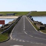

OIC to survey first barrier

Surveys are due to be carried out on the first Churchill Barrier, next week, Orkney Islands Council has confirmed.
The work will aim to establish whether structural issues deep within the causeway could be causing an uneven road surface.
The council say that, although resurfacing work has been carried out in the past, feedback from road users has been that the surface is uneven. The concern is that, although resurfacing and general maintenance continues to be done, this may not fix the issue in the long-term.
OIC has now engaged a specialist team to look at the issue, who’ll be deploying state of the art equipment to take radar readings through the causeway down to sea level, providing valuable information on its deep make-up.
This data will then be used to come up with options for short and long-term maintenance of the road, with general inspections and periodic minor repairs continuing until the results of the survey are fully considered.
Due to the nature of the work, there will unfortunately be road closures and a convoy system in place on the evening of Monday 8 July. The work has been scheduled for between 8.30pm and 11.00pm to minimise disruption, by ensuring that traffic from the last Pentland Ferries arrival has passed through. Delays of up to 20 minutes are possible.
The work will begin with coring taking place, which sees four small cylindrical sections of the road removed, analysed and then replaced. This allows the contractors to identify the make-up of the top layers of the road and calibrate their equipment accordingly.
The second stage of the work sees a specialist vehicle driven at usual traffic speed across the barrier a number of times, taking video and radar footage as it moves.
The third and final stage sees a piece of hand-pushed equipment moved across the barrier at walking speed taking Ground Penetrating Radar (GPR) data of the full depth of the structure as it goes. The GPR system emits short duration pulses of electromagnetic energy. These pulses or scans are transmitted into the road and reflections from material boundaries or embedded features (like voids) are detected by a receiver. Through analysis of the reflected signals a continuous 3D model of the Barrier can then be provided, determining material thickness and construction changes. This should therefore determine what, if any, underlying defects there are within the matrix of the causeway. The survey allows data to be taken down to depths of five metres.
The video survey will provide a high resolution and spatially referenced video to enable the visual condition of the surface to be assessed to sub-metre accuracy. This will be matched with the GPR survey to produce a visual model to pinpoint anomalies in the surfacing.
John Wrigley, OIC roads and environmental services manager said: “As a key element of Orkney’s travel network, we keep a keen eye on the state of this road.
“Our ongoing monitoring has shown that the surface continues to deteriorate despite previous interventions — which would suggest that resurfacing is not going to fix the problem in the long-term.
“We now need to carry out this important piece of work to see if there could be a more deep-rooted reason for the issues — which should lead us to an appropriate and cost-effective solution.”
“Previous survey work has given us detailed information on the top layers of the road, but this new survey will look deep into the construction for voids or other potential failures. We apologise for the delays that this survey will cause on the night of 8 July – but we’re sure that local road users will understand that this is necessary as part of finding a long term solution to improving the structure of the road. We’d ask that road users take their time in the vicinity on the night and would also take the opportunity to remind people of the 40mph advisory speed limit that already exists on the first Barrier.”
East Mainland, South Ronaldsay and Burray councillor, Andrew Drever added: “I accept the concerns that have been raised over a period of time, particularly by motorcyclists, and I am pleased to see this piece of work getting underway.
“Once we have the survey results, we’ll be able to look at options and hopefully find a way forward in a short a timescale as possible.”