
Investigating the old shoreline of Kirkwall
The Archaeology Institute UHI has been given the go ahead to start the first stage of a survey to investigate Kirkwall’s old shoreline.
Work is due to take place on Thursday and Friday this week.
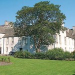
The project is a community focused archaeological project in which six volunteers will receive training in the use of geophysical survey techniques including magnetometry, earth resistance and ground penetrating radar. The proposed location of the initial survey — the grounds of Tankerness House (which houses the Orkney Museum) and Royal Bank of Scotland gardens — will, it is hoped, help to answer the following research questions:
- What is the location, character and depth of the former shoreline and piers to the west of the town centre of Kirkwall (between Broad Street and Junction Road)?
- Is there any evidence for the former layout of the Tankerness House gardens?
- Do remains of the range of buildings depicted on the 1882 Ordnance Survey map in the southern part of the museum gardens survive below ground level? If so, what is the character and depth of these remains?
Discovering Hidden Kirkwall is part of The Kirkwall Townscape Heritage Initiative Archaeological Programme and is being led by the institute’s lifelong learning and outreach archaeologist, Dan Lee. The project is funded by the Heritage Lottery Fund and supported by OIC.
You can follow developments and view photographs on the institutes’s blog.