
Batten down the hatches, says Orkney emergency group
The multi-agency Orkney Local Emergency Co-ordinating Group (OLECG) is advising the community to be prepared for severe weather conditions.
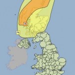
The group met today in response to predictions of very strong winds expected to affect Orkney from midnight tonight and into tomorrow morning.
The Met Office has issued an Amber “be prepared” warning for the Northern Isles, with gusts of 80 to 90 mph forecast.
Chief Inspector Eddie Graham, Police Scotland’s area commander for Orkney and chair of OLECG, said: “Our aim is to ensure that key agencies are prepared for eventualities linked to the weather conditions predicted.
“As the forecast stands, exposed coastal roads and causeways could be affected by spray and possible over-topping by waves,” he said.
“Thundery showers are also forecast and we all know from recent experience that lightning can cause disruption to power supplies and damage to household appliances.
“Given the strength of the winds that are predicted, disruption and timetable changes are also likely on internal and external ferry routes. Our advice is to keep an eye on weather forecasts and keep in touch with transport providers.”
With some localised flooding anticipated in St Mary’s and St Margaret’s Hope, Orkney Islands Council is putting in place temporary flood prevention measures.
Chief Inspector Graham added: “With strong winds, there is always the possibility that some homes may be affected by a loss of power. In those circumstances, we would ask friends, family and neighbours to keep an eye on people who may be experiencing problems as a result.
“We would ask that people ensure that anything that could be blown about is safely stowed away or tied down – strips of plastic or polythene, for instance, can cause power cuts if they get wrapped around power lines.
“This is the first storm of the winter. People in Orkney are well used to weather conditions of this kind and to taking the common sense precautions required when strong winds and lightning are forecast.”