
Weather warning prompts emergency meeting

(www.theorcadianphotos.co.uk)
OLECG, the Orkney Local Emergency Co-ordination Group, met today in response to forecasts of serious flooding throughout the county.
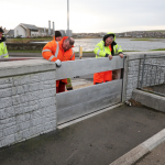
Kirkwall’s harbour front flood gates are being put in place today in response to latest weather forecasts.
The Scottish Environment Protection Agency (SEPA) has issued Flood Warnings for Kirkwall, Stromness, St Mary’s and Graemeshall, Scapa, Burray, the Churchill Barriers, St Margaret’s Hope, Longhope and Hoy, Stronsay, Westray and Sanday. Full details here: http://www.floodlinescotland.org.uk/flood-updates/
Chief Inspector Matt Webb, area commander for Police Scotland, who chaired the meeting, said: “Serious coastal flooding, potentially some of the worst we’ve seen since 2005, is forecast for many areas of Orkney.
“At present, Stromness, St Margaret’s Hope, Burray, Longhope and parts of Westray and Sanday look likely to be worst affected.”
Sandbags are being made available for collection from pallets placed at Cromarty Square, St Mary’s, Burray village, Scapa and Garson in Stromness. Sandbags will also be available in Westray, Hoy and Sanday.
The council has also deployed temporary flood prevention equipment at Cromarty Square in St Margaret’s Hope.
He added: “In Kirkwall, drivers who use the Waterfront West-Shapinsay Slip carpark and Kirkwall Harbour are asked to move vehicles as soon as possible. Vehicles will be unable to leave this area once flood gates are fully deployed.”
The flood defence scheme is designed to protect low lying parts of Kirkwall against flooding from the sea.
When forecasts predict a risk of flooding, flood gates are fitted across gaps in the stone wall along the harbour front – creating a 1.1-metre-high uninterrupted barrier between Ayre Mills and St Catherine’s Place roundabout.
The main gates at the Waterfront West-Shapinsay Slip and Kirkwall Harbour entrance will be closed as late as possible to allow vehicles to move in and out.
SEPA advises that the highest risk of flooding will be a few hours either side of the high tide on Tuesday around 12 noon. There may also be a risk of wave overtopping at high tide at around midnight tonight.
Latest updates will be available on the OIC Updates Facebook page and at: https://twitter.com/OIC_Roads